Save as PDF
Washington State Recreation and Conservation Office
Project Snapshot
PRISM Project #08-2060 (Completed)
Lower Icicle Creek Habitat Conservation
    Project Details    
Chelan-Douglas Land Trust; Lower Icicle Creek Habitat Conservation (#08-2060)

06/13/2013, Attachment #167212, Icicle River from Trail Access - upstream
Chelan-Douglas Land Trust; Lower Icicle Creek Habitat Conservation (#08-2060) 06/13/2013, Attachment #167212, Icicle River from Trail Access - upstream

Chelan-Douglas Land Trust; Lower Icicle Creek Habitat Conservation (#08-2060)

06/13/2013, Attachment #167212, Icicle River from Trail Access - upstream Chelan-Douglas Land Trust; Lower Icicle Creek Habitat Conservation (#08-2060)

Attachment #63380, Fromm_Riparian flooding2, low resChelan-Douglas Land Trust; Lower Icicle Creek Habitat Conservation (#08-2060)

Attachment #63384, Fromm_Riparian flooding4, low resChelan-Douglas Land Trust; Lower Icicle Creek Habitat Conservation (#08-2060)

Attachment #63395, Fromm Family Parcels, low resChelan-Douglas Land Trust; Lower Icicle Creek Habitat Conservation (#08-2060)

05/30/2008, Attachment #65346, Fromm Pasture and Riparian, Landscape ViewChelan-Douglas Land Trust; Lower Icicle Creek Habitat Conservation (#08-2060)

05/30/2008, Attachment #65348, Fromm Pasture and Riparian, Streamside ViewChelan-Douglas Land Trust; Lower Icicle Creek Habitat Conservation (#08-2060)

05/30/2008, Attachment #65351, Fromm Riparian PlantingsChelan-Douglas Land Trust; Lower Icicle Creek Habitat Conservation (#08-2060)

Attachment #122463, Fromm Phases MapChelan-Douglas Land Trust; Lower Icicle Creek Habitat Conservation (#08-2060)

Attachment #122465, Lower Icicle Ownership MapChelan-Douglas Land Trust; Lower Icicle Creek Habitat Conservation (#08-2060)

04/05/2011, Attachment #129345, Phase 1 wetland/low spotChelan-Douglas Land Trust; Lower Icicle Creek Habitat Conservation (#08-2060)

04/05/2011, Attachment #129346, Phase 1 bank protection, upstream endChelan-Douglas Land Trust; Lower Icicle Creek Habitat Conservation (#08-2060)

04/05/2011, Attachment #129347, Phase 1 with Phase 2 in background (house)Chelan-Douglas Land Trust; Lower Icicle Creek Habitat Conservation (#08-2060)

04/05/2011, Attachment #129348, Phase 1 HabitatChelan-Douglas Land Trust; Lower Icicle Creek Habitat Conservation (#08-2060)

11/15/2012, Attachment #154906, Gravel Parking AreaChelan-Douglas Land Trust; Lower Icicle Creek Habitat Conservation (#08-2060)

11/15/2012, Attachment #154908, East End of Gravel Parking AreaChelan-Douglas Land Trust; Lower Icicle Creek Habitat Conservation (#08-2060)

11/15/2012, Attachment #154912, Looking East from Fishing PlatformChelan-Douglas Land Trust; Lower Icicle Creek Habitat Conservation (#08-2060)

11/15/2012, Attachment #154913, Looking upstream - westChelan-Douglas Land Trust; Lower Icicle Creek Habitat Conservation (#08-2060)

11/15/2012, Attachment #154914, Gravel Parking looking eastChelan-Douglas Land Trust; Lower Icicle Creek Habitat Conservation (#08-2060)

12/10/2012, Attachment #155444, Public Access areaChelan-Douglas Land Trust; Lower Icicle Creek Habitat Conservation (#08-2060)

04/30/2013, Attachment #163077, Stump Hole Kiosk with Jason & MattChelan-Douglas Land Trust; Lower Icicle Creek Habitat Conservation (#08-2060)

04/30/2013, Attachment #163078, Kiosk CloseupChelan-Douglas Land Trust; Lower Icicle Creek Habitat Conservation (#08-2060)

06/13/2013, Attachment #167209, New KioskChelan-Douglas Land Trust; Lower Icicle Creek Habitat Conservation (#08-2060)

06/13/2013, Attachment #167210, New Kiosk with Cascades in BackgroundChelan-Douglas Land Trust; Lower Icicle Creek Habitat Conservation (#08-2060)

06/13/2013, Attachment #167211, Icicle River from Trail Access - downstream
Project Status:  Closed Completed since 05/02/2013
 
Project Type:  Acquisition
Project Sponsor:  Chelan-Douglas Land Trust
Funding Board:  Salmon Recovery Funding Board
              Funding  
Salmon Federal Projects: $322,606
Salmon State Projects: $18,559
Total RCO Grant: $341,165 (78%)
Sponsor Match: $95,550 (22%)
Total Agreement: $436,715 (100%)
              Links
 

    Project Description    
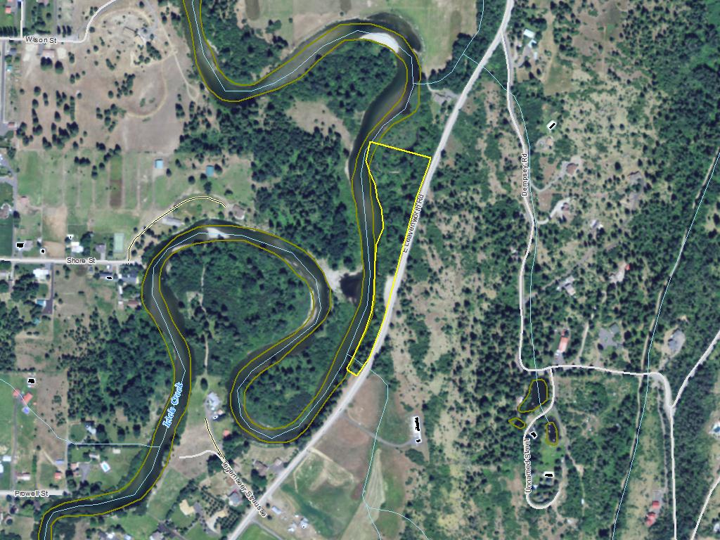
We request partial funding to acquire a conservation easement on 15 acres of floodplain on Lower Icicle Creek, a tributary to Wenatchee River. This easement will cover property that is 85% within the 100-year floodplain, designated by FEMA. The conservation easement will address the following protection elements in the floodplain: extinguishment of all development rights, plus a prohibition of paved roads, clearing and grading, wetland filling or draining, and agriculture. This project protects up to 3,155 feet of streambankand is the first of two phases of protection.

The Upper Columbia Recovery Plan states that “the highest priority for protecting biological productivity should be to allow unrestricted stream channel migration, complexity, and flood plain function. The principal means to meet this objective is to protect riparian habitat in Category 1 and 2 subwatersheds.” Icicle Creek is a Category 2 Watershed, a Minor Spawning Area for spring Chinook salmon, a Major Spawning Area for steelhead, and a Core Area for bull trout. The Recovery Plan also sets the Tier 3 Strategy for Icicle Creek to “protect existing riparian habitat and channel migration and floodplain function” and recommends “acquire conservation easements where appropriate from Leavenworth Hatchery to the mouth.” This project is in that reach and is an important corridor for migration, adult holding, juvenile rearing, and overwintering.

    Project Contacts    
         
Project Sponsor: Chelan-Douglas Land Trust Lead Entity: Upper Columbia Salmon Recovery Board Lead Entity
  Project Contact: Mickey Fleming
mickey@cdlandtrust.org
(509) 667-9708
   
 
Funding Agency: Recreation and Conservation Office    
  Project Manager: Amee Bahr
Amee.Bahr@rco.wa.gov
(360) 867-8585
   

    Project Location    
General Area:   South of Leavenworth
Waterbody:   Icicle Creek, Wenatchee River
County:   Chelan
Legislative District:   12
Congressional District 2022:   08
Salmon Recovery Regions:   Upper Columbia River
Watershed Administrative Unit:   Enchantment
HUC8:   Wenatchee (17020011)
WRIA:   Wenatchee
Sections:   13
Township:   T24NR17E
Coordinates:   47.57598960
-120.66377481

    Worksites    
Worksite NameScope of Work
Fromm Family (#1) Administrative costs (Acq), Easement, Land, Signs (Acq), Standard Incidentals, Stewardship plan
  
Amounts may not be complete

    Properties    
Worksite Name Property Name Actual Acquisition
Acres
Actual Acquisition
Cost
Fromm Family (#1)   Property 1 - Private Landowner 0.00 $50,561
Fromm Family (#1)   Property 2 - Private Landowner 6.45 $391,478
   Total6.45$442,039
Amounts may not be complete

    Project Milestones    
Milestone NameTarget DateDescription
Project Start 12/12/2008
Order Appraisal Review(s) 06/30/2009
Annual Project Billing Due 07/31/2009
Annual Project Billing Due 07/31/2010
Annual Project Billing Due 07/31/2011
Special Conditions Met 09/30/2011 Comply with Governor’s Executive Order 05-05
Purchase Agreement Signed 07/31/2012 Acquisition Option Chosen by Seller
Purchase Agreement Signed 12/11/2012 Signature Date by all Family Members
Acquisition Closing 01/15/2013
Agreement End Date 03/31/2013
Final Billing Due 06/30/2013


    Project Attachments    
Attachment TypeAttachment TitleAttach Date
Agreement - State Agreement.pdf 05/22/2009
Amendment request Easement Amendment Request.pdf 06/30/2011
Certification of Applicant Match Icicle Fund Grant Approval.pdf 11/19/2012
Correspondence Fromm Just Compensation 12-20-12.pdf 12/21/2012
Correspondence WDFW Memo E. Leavenworth Rd Parcel 9 22 12.docx 10/10/2012
Correspondence Time Ext. Request 06.22.12.pdf 07/09/2012
Correspondence Match Reduct Request - Approv 08-15-11.docx 08/15/2011
Correspondence Fromm CE Funding Summary110308.pdf 11/06/2008
Cost Estimate E. Leavenworth Rd. Proposed Budget.xlsx 11/26/2012
Cost Estimate Signage Kiosk Proposal 10 29 12 (2).docx 10/29/2012
Deed of right DOR Stump Hole 02-15-13.pdf 04/10/2013
Deed or title Stump Hole SWD 12-28-12.pdf 02/04/2013
Environmental Assessment (EA) Environ Site Assess Phase 1 12-05-11.pdf 12/09/2011
Environmental Site Assessment Report Stump Hole Archy Monitor Report 04-09-13.pdf 04/24/2013
Final project report Final Report 05/02/2013.pdf 05/02/2013
Hazardous Substance Certification Form Stump Hole Haz Subst Certif 12-12-12.pdf 12/12/2012
Inspection Report Inspection Report, #1667 (Accepted 12/30/18 11:41:01).pdf 12/30/2018
Inspection Report Interim Inspection Photos 11-15-12.pptx 11/29/2012
Landowner acknowledgement form Landowner Acknowledgment Phases 2 & 3 parcels.pdf 05/19/2011
Landowner acknowledgement form Fromm Acknowlegdement Form.pdf 07/31/2008
Landowner agreement Signed Letter of Intent.pdf 06/30/2011
Legal description Legal Descriptions for CE Parcels.docx 11/03/2011
Map Stump Hole Maps & Photos.pdf 02/04/2013
Map Fromm CE map 11-02-11.pdf 11/03/2011
Map Lower Icicle Ownership Map.jpg 07/15/2011
Map Icicle Consevation Area Map.pdf 07/15/2011
Map Fromm Phases Map.jpg 07/15/2011
Map Icicle - Fromm CE - Phases Map.docx 03/25/2011
Map Lower Icicle Creek County Zoning .pdf 07/31/2008
Map Lower Icicle FEMA 100-yr. Floodplain Map.pdf 07/31/2008
Map Phase 1 - Phase 2 Map-Ortho Photo July 2008.pdf 07/27/2008
Map Fromm Family Parcels, low res.jpg 07/09/2008
News Article 05-22-08 Wenatchee World News Article.pdf 07/27/2008
Notice of Long-Term Obligations Chelan-Douglas Land Trust 2014 Sponsor Notice.pdf 10/24/2014
Photo 10-29-18 Compliance Inspection 5.jpg 12/30/2018
Photo 10-29-18 Compliance Inspection 1.jpg 12/30/2018
Photo 10-29-18 Compliance Inspection 2.jpg 12/30/2018
Photo 10-29-18 Compliance Inspection 3.jpg 12/30/2018
Photo 10-29-18 Compliance Inspection 4.jpg 12/30/2018
Photo 10-29-18 Compliance Inspection.jpg 12/30/2018
Photo Icicle River from Trail Access - upstream.jpg 06/19/2013
Photo Icicle River from Trail Access - downstream.jpg 06/19/2013
Photo New Kiosk with Cascades in Background.jpg 06/19/2013
Photo New Kiosk.jpg 06/19/2013
Photo Kiosk Closeup.jpg 05/01/2013
Photo Stump Hole Kiosk with Jason & Matt.jpg 05/01/2013
Photo Public Access area.jpg 12/10/2012
Photo Gravel Parking looking east.jpg 11/29/2012
Photo Looking upstream - west.jpg 11/29/2012
Photo Looking East from Fishing Platform.jpg 11/29/2012
Photo East End of Gravel Parking Area.jpg 11/29/2012
Photo Gravel Parking Area.jpg 11/29/2012
Photo Phase 1 Habitat.jpg 11/17/2011
Photo Phase 1 with Phase 2 in background (house).jpg 11/17/2011
Photo Phase 1 bank protection, upstream end.jpg 11/17/2011
Photo Phase 1 wetland/low spot.jpg 11/17/2011
Photo Fromm Riparian Plantings.jpg 07/31/2008
Photo Fromm Pasture and Riparian, Streamside View.jpg 07/31/2008
Photo Fromm Pasture and Riparian, Landscape View.jpg 07/31/2008
Photo Fromm_Riparian flooding4, low res.jpg 07/09/2008
Photo Fromm_Riparian flooding2, low res.jpg 07/09/2008
Progress report Progress Report 07/12/2011.pdf 07/12/2011
Project presentation 4 slide Icicle Creek PP.pptx 07/14/2011
Salmon Project Proposal Tributary Fund Application 08.01.08.pdf 08/01/2008
Stewardship plan Stump Hole Steward Plan Final 11-04-12.pdf 11/26/2012
Survey-Property Boundary Survey Parcel B East Leavenworth Rd .pdf 11/03/2011
Survey-Property Boundary Survey Parcel A Wilson Street.pdf 11/03/2011
Title Insurance Stump Hole Final Title Insurance 12-28-12.pdf 02/04/2013
Visuals Sign Site Rules.pdf 04/30/2013
Visuals Sign Salmon Habitat.pdf 04/30/2013
Visuals Sign Salmon Life Cycle.pdf 04/30/2013

Back to top Date of last change: 04/16/2024