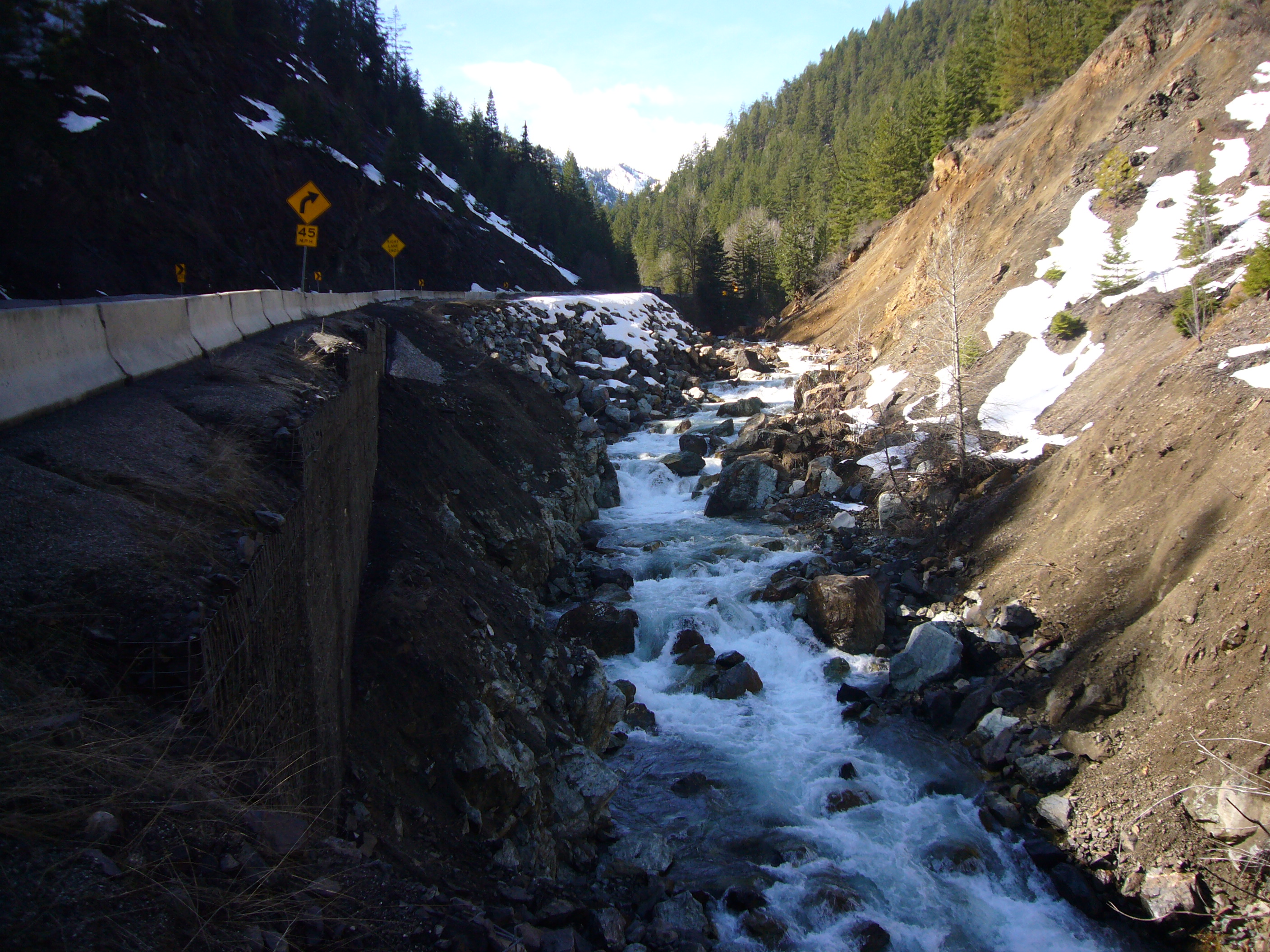
Upper Peshastin Barrier Conceptual Design

|
Chelan Co Natural Resource; Upper Peshastin Barrier Conceptual Design (#14-1739)
03/22/2016, Attachment #272777, Study Area for Passage Correction 03-22-16
|
|
|
|
|
The project will assess the existing geologic conditions of the Ruby Slide, existing fish passage conditions to determine what is the limiting factor(s) for passage past this reach, develop conceptual designs for project alternatives, and to coordinate with stakeholders (USFS, WSDOT and WDFW) to evaluate and select a preferred alternative conceptual design.
Currently, a 1000’ reach of Peshastin Creek, (RM 10.4-10.6) is believed to be limiting access to spawning habitat upstream. Spawning distribution and timing data, as well as field observations, suggest that a landslide above the Ruby Creek confluence may be acting as a barrier at low flows, thus inhibiting access to high quality spawning areas and delaying the spawn timing of fish that eventually access habitat above the slide by over 40 days. The upper Peshastin Creek and tributaries above this reach provide diverse habitat types and substantial low gradient spawning habitat. Road building alteration to the channel has been exacerbated in this reach by the failure of the slope above the reach (The Ruby Slide), and WSDOT repairs to this stretch of US 97. The resulting channel is severely constricted between vertical gabion baskets and the toe of a 16 acre slide path. Spawning surveys conducted by WDFW throughout the Wenatchee basin from 2004 - 2010 demonstrate steelhead spawning in Peshastin Creek contributes significantly to the basin as a whole. In 2010, Peshastin Creek had 12.2% of the steelhead redds in the Wenatchee subbasin. The majority of the spawning is distributed in the lower Peshastin between RM 3 to 6.5. In the upper Peshastin steelhead show a pattern of concentrated spawning between Ingalls and Ruby Creek with dispersed spawning beyond the project site and in Tronsen Creek.
|
|
General Area:
|
|
Upper Peshastin, along US 97
|
|
County:
|
|
Chelan
|
|
Legislative District:
|
|
12
|
|
Congressional District 2022:
|
|
08
|
|
Salmon Recovery Regions:
|
|
Upper Columbia River
|
|
Watershed Administrative Unit:
|
|
Blewett
|
|
HUC8:
|
|
Wenatchee (17020011)
|
|
WRIA:
|
|
Wenatchee
|
|
Sections:
|
|
36
|
|
Township:
|
|
T23NR17E
|
|
Coordinates:
|
|
47.44855564
-120.65629627
|
|
|
Amounts may not be complete
| | Category / Work Type / Metric | Final |
Restoration Metrics (rolled up from Worksite level) |
|
| |
|
|
Area Encompassed (acres) (B.0.b.1)
|
1.0
|
|
|
Miles of Stream and/or Shoreline Affected (B.0.b.2)
|
0.20
|
| Milestone Name | Target Date | Description |
|
Project Start
|
12/04/2014
|
|
|
Data Gathering Started
|
04/20/2015
|
|
|
RFP Complete/Consultant Hired
|
04/20/2015
|
|
|
Progress Report Due
|
06/30/2015
|
|
|
Special Conditions Met
|
07/24/2015
|
Provide geologic assessment report of Ruby Slide to SRFB Review Panel.
|
|
Annual Project Billing Due
|
07/31/2015
|
|
|
Special Conditions Met
|
08/24/2015
|
SRFB Review Panel approves or denies continuing with design process.
|
|
Progress Report Due
|
12/31/2015
|
|
|
Progress Report Due
|
06/30/2016
|
|
|
Annual Project Billing Due
|
07/31/2016
|
|
|
Special Conditions Met
|
08/31/2016
|
Letters of Support from the USFS and WSDOT for the preferred alternative.
|
|
Draft Design to RCO
|
02/01/2017
|
Draft Conceptual Design.
|
|
Agreement End Date
|
03/31/2017
|
|
|
Final Design to RCO
|
04/03/2017
|
Final Conceptual Design.
|
|
Final Report Due
|
06/30/2017
|
|
|
Final Billing Due
|
06/30/2017
|
|