Nason N1-KDIZ3 Floodplain Reconnection
|
|
| Funding |
|
|
Salmon State Projects:
|
$621,000
|
|
|
Total RCO Grant:
|
$621,000
|
(85%)
|
|
Sponsor Match:
|
$110,000
|
(15%)
|
|
Total Agreement:
|
$731,000
|
(100%)
|
|
|
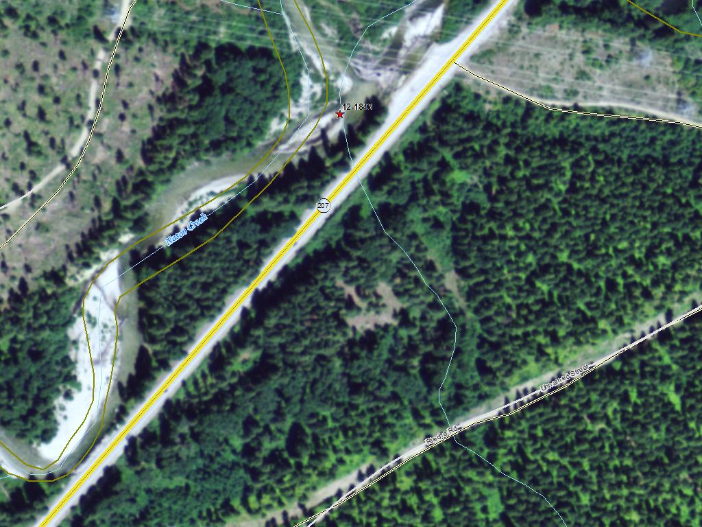
The Chelan County Natural Resource Department will use this grant to reconnect Nason Creek to 13 acres of floodplain habitat by increasing the size of two culverts under State Route 207. The re-alignment of State Route 207 in the 1940s disconnected Nason Creek from the adjacent floodplain in several areas. Nason Creek contains major spawning areas for endangered spring Chinook salmon and endangered steelhead, and it is an important area for bull trout, which are listed as threatened with extinction under the federal Endangered Species Act. The department looked at moving the state highway, but that was too expensive. The project is just downstream from Coles Corner near State Route 207. The County will contribute $110,000 from another grant. See more information on this project. (12-1843)
|
|
General Area:
|
|
Near Cole's Corner on US 2
|
|
County:
|
|
Chelan
|
|
Legislative District:
|
|
12
|
|
Congressional District 2022:
|
|
08
|
|
Salmon Recovery Regions:
|
|
Upper Columbia River
|
|
Watershed Administrative Unit:
|
|
Lower Nason
|
|
HUC8:
|
|
Wenatchee (17020011)
|
|
WRIA:
|
|
Wenatchee
|
|
Sections:
|
|
09
|
|
Township:
|
|
T26NR17E
|
|
Coordinates:
|
|
47.76345733
-120.73121298
|
|
|
| Worksite Name | Scope of Work | Proposed Restoration Cost |
|
N1-KDIZ3 Floodplain Reconnection (#1)
|
Architectural & Engineering (A&E), Channel reconfiguration and connectivity (C.4.c.1), Cultural resources, Culvert installed or improved (C.2.f.1), Implementation monitoring, Obtain permits
|
$731,000
|
| | Total | $731,000 |
Amounts may not be complete
| Worksite Name | | Property Name | Landowner Type |
|
N1-KDIZ3 Floodplain Reconnection (#1)
|
|
Property 1 - N1-KDIZ3
|
Federal Government
|
| | | | Total |
Amounts may not be complete
| | Category / Work Type / Metric | Estimated |
Restoration Metrics (rolled up from Worksite level) |
Instream Habitat Project |
| Channel reconfiguration and connectivity (C.4.c.1) |
|
|
Miles of Stream Treated for channel reconfiguration and connectivity (C.4.c.3)
|
0.30
|
|
|
Miles of Off-Channel Stream Created or Connected (C.4.c.4)
|
0.34
|
|
|
Acres Of Channel/Off-Channel Connected Or Added (C.4.c.5)
|
13.0
|
Permits |
| Obtain permits |
|
|
Number of permits required for implementation of project
|
5
|
Fish Passage Improvement |
| Culvert installed or improved (C.2.f.1) |
|
|
Miles of stream made accessible by culvert installation/repair (C.2.f.3)
|
0.10
|
|
|
Number of culverts (C.2.f.2)
|
2
|
| Permit Type | Applied
Date | Received
Date | Expiration
Date | Permit Number |
|
Archeological & Cultural Resoures (EO 05-05)
|
|
|
|
|
|
Cultural Assessment [Section 106]
|
|
|
|
|
|
Endangered Species Act Compliance [ESA]
|
|
|
|
|
|
Hydraulics Project Approval [HPA]
|
|
|
|
|
|
Nationwide Permit
|
|
|
|
|