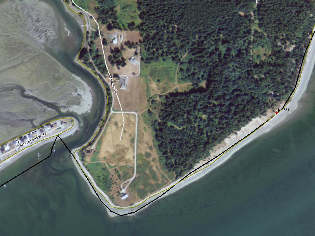
Barnum Point Acquisition - Phase I (ESRP)
 (#11-1651)
Attachment #127129, Barnum Point Photo 1")
|
The Nature Conservancy; Barnum Point Acquisition - Phase I (ESRP) (#11-1651)
Attachment #127129, Barnum Point Photo 1
|
|
|
|
|
The overall goal of the Barnum Point project is to permanently protect ~48 acres of tidelands, forested shoreline and associated uplands on Camano Island, thereby conserving intact habitat, ecological processes and public access. The project will occur in a single phase with the following specific objectives:
- Acquire 48 acres (18 tideland acres & 30 upland acres) and 0.43 miles of intact shoreline through a combination of fee and conservation easement.
- Protect an exceptional feeder bluff that supplies sediment to Port Susan Bay.
80% of shorelines in Island County have private residences, leading to armoring, overwater structure installation and water quality issues. An hour from Seattle, Camano Island has high development pressure due to its desirability for commuters and second homes. The current owners are actively marketing the property and zoning allows for 5 additional homes within proposed the fee acquisition area.
Directly adjacent to 7,100 acres of already protected aquatic lands, Barnum Point is a priority both for its high-quality habitats and the habitat-forming processes it sustains. Important features include: an actively eroding feeder bluff; intact shoreline and nearshore habitat utilized by all 8 species of salmon that spawn in the Skagit and Stillaguamish Rivers; forage fish spawning sites; and marine riparian forest.
The site will be managed as a county-owned passive-use natural recreation area. It will provide outstanding passive recreation opportunities-addressing the expressed need for shoreline access in Island County and across the Sound while preserving the habitats, features and processes the site sustains.
|
|
General Area:
|
|
East side of Camano Island on Port Susan Bay.
|
|
County:
|
|
Island
|
|
Legislative District:
|
|
10
|
|
Congressional District 2022:
|
|
02
|
|
Salmon Recovery Regions:
|
|
Puget Sound
|
|
Watershed Administrative Unit:
|
|
Camano Island
|
|
HUC8:
|
|
Puget Sound (17110019)
|
|
WRIA:
|
|
Island
|
|
Sections:
|
|
05
|
|
Township:
|
|
T31NR03E
|
|
Coordinates:
|
|
48.19649545
-122.45524088
|
|
|
| Worksite Name | Scope of Work |
|
Barnum Point (#1)
|
Administrative costs (Acq), Boundary line adjustment, Cultural resources (Acq), Easement, Land, Noxious weed control, Signs (Acq), Standard Incidentals, Survey (Acq)
|
| | |
Amounts may not be complete
| Worksite Name | | Property Name | | Actual Acquisition
Acres | Actual Acquisition
Cost |
|
Barnum Point (#1)
|
|
Property 1 - Private Landowner
|
|
26.00
|
$2,096,451
|
| | | | Total | 26.00 | $2,096,451 |
Amounts may not be complete
| Milestone Name | Target Date | Description |
|
Project Start
|
07/01/2011
|
|
|
Order Appraisal(s)
|
07/31/2011
|
|
|
Purchase Agreement Signed
|
01/31/2012
|
|
|
Order Appraisal Review(s)
|
02/29/2012
|
|
|
Environmental Assess Complete
|
03/31/2012
|
|
|
Progress Report Due
|
05/31/2012
|
|
|
Baseline Documentation to RCO
|
06/30/2012
|
|
|
Progress Report Due
|
07/31/2012
|
|
|
Annual Project Billing Due
|
07/31/2012
|
|
|
Acquisition Closing
|
07/31/2012
|
|
|
Recorded Acq Documents to RCO
|
09/30/2012
|
|
|
Recorded Land Survey to RCO
|
09/30/2012
|
|
|
Progress Report Due
|
04/30/2013
|
|
|
Special Conditions Met
|
06/30/2013
|
Compliance with Scope of Work
|
|
Stewardship Plan to RCO
|
06/30/2013
|
|
|
Agreement End Date
|
06/30/2013
|
|
|
Annual Project Billing Due
|
07/31/2013
|
|
|
Final Report Due
|
09/30/2013
|
|
|
Final Billing Due
|
09/30/2013
|
|