BNSF Railroad and Wenatchee Basin Coordination

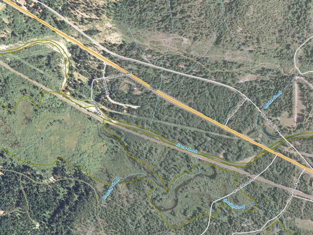
Attachment #154652, LIDAR image of disconnected floodplain-jpg")
|
Chelan Co Natural Resource; BNSF Railroad and Wenatchee Basin Coordination (#07-1885)
Attachment #154652, LIDAR image of disconnected floodplain-jpg
|
|
|
|
|
In response to recommendations provided by the Upper Columbia River Technical Team (UCRTT) (2007b) and the Upper Columbia Salmon Recovery Board (UCSRB) (2006), the Chelan County Natural Resource Department (CCNRD) seeks funding to develop a project proposal and review process with the Burlington Northern and Santa Fe (BNSF) Railroad that will facilitate the implementation of projects on BNSF land. In order to accomplish this task, the CCNRD will work to build a coalition of support, including stakeholders such as state representatives and the tribes. The CCNRD will work with BNSF representatives to identify data requirements for engineering evaluations, determine project approval criteria, and establish an official proposal, review, and approval process prior to specific project proposals.
Throughout the Wenatchee subbasin, the construction of channel confining features such as the roads and railroads has straightened and simplified existing stream channels, disconnected off-channel habitat and floodplain, and generally resulted in the degradation of the habitat required for ESA listed salmonids. The elimination of channel complexity and off-channel habitat are primary habitat limiting factors (HLF) throughout the Wenatchee subbasin and have thus been identified as top priorities for restoration projects. By creating a review and approval process with BNSF, this project seeks to gain access to valuable, yet disconnected, off-channel and floodplain habitat.
|
|
General Area:
|
|
Nason Creek flows out of Lake Valhalla near Stevens Pass and flows east for approximately 21 miles before heading north and flowing into the Wenatchee River immediately below Lake Wenatchee at RM 53.6
|
|
County:
|
|
Chelan
|
|
Legislative District:
|
|
12
|
|
Congressional District 2022:
|
|
08
|
|
Salmon Recovery Regions:
|
|
Upper Columbia River
|
|
Watershed Administrative Unit:
|
|
Lower Nason
|
|
HUC8:
|
|
Wenatchee (17020011)
|
|
WRIA:
|
|
Wenatchee
|
|
Sections:
|
|
11
|
|
Township:
|
|
T26NR16E
|
|
Coordinates:
|
|
47.77175591
-120.81726311
|
|
|
| Worksite Name | Scope of Work | Actual Planning Cost |
|
Nason Creek Example (#1)
|
Conducting habitat restoration scoping and feasibility studies (B.1.b.8)
|
$55,209
|
| | Total | $55,209 |
Amounts may not be complete
| Worksite Name | | Property Name | Landowner Type |
|
Nason Creek Example (#1)
|
|
Property 1 - Nason Creek
|
Private
|
| | | | Total |
Amounts may not be complete
| | Category / Work Type / Metric | Final |
Restoration Metrics (rolled up from Worksite level) |
|
| |
|
|
Area Encompassed (acres) (B.0.b.1)
|
581.8
|
| Milestone Name | Target Date | Description |
|
Project Start
|
12/13/2007
|
|
|
RFP Complete
|
01/01/2008
|
|
|
Bid Awarded/Consultant Hired
|
01/01/2008
|
|
|
Data Gathering Started
|
01/01/2008
|
|
|
Special Conditions Met
|
01/29/2008
|
Compliance with Executive Order 05-05 (cultural resources) was met via the Department of Archaeology & Historic Preservation letter concurring that this project is exempt.
|
|
Annual Project Billing Due
|
07/31/2009
|
|
|
Draft Rpt Reviewed by Mgmt Agy
|
06/28/2010
|
|
|
Annual Project Billing Due
|
07/31/2010
|
|
|
Final Report Completed
|
08/31/2010
|
|
|
Agreement End Date
|
08/31/2010
|
|
|
Final Docs/Billing to Mgmt Agy
|
11/30/2010
|
|